Library Catalog
Latest Documents and Publications listed. Use search terms in the box below to find what you need
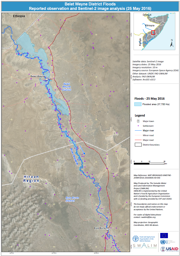
Belet Weyne District Reported Floods observation and Sentinel-2 image analysis (25 May 2016)
This dataset was digitized directly from Sentinel-2 imagery of 25th May 2016 to show the areal extent of Belet Weyne flooding. Sentinel-2 image resolution of 10m was downloaded free of charge from European Space Agency (ESA)
Publication Type:
Map
Publication Date:
Author:
Corporate Author:
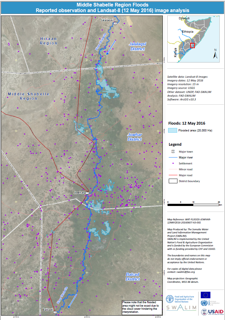
Middle Shabelle Region Floods Reported observation and Landsat-8 (12 May 2016) image analysis
This dataset was digitized directly from Landsat-8 imagery of 12th May 2016 to show the areal extent of Jowhar flooding. Please note that the flooded area might not be exact due to the cloud cover hindering the interpretation. Landsat-8 image resolution of 15m was downloaded free of charge from USGS Earth Explorer
Publication Type:
Map
Publication Date:
Author:
Corporate Author:
Daadadka Gobolka Shabeellaha Dhexe oo looga warbixiyay jeedaalinta iyo falanqaynta muuqaal sawirka
Xog ururin taan si toos ah ayaa looqoray iyadoo digital ah oo laga soo tafsiiray sawirka Landsat -8 iyo 12-kii May 2016 si loo muujiyo xadka bedka fatahaadda ay ka gaartey Jowhar. Fadlan la soco in laga yaabaa in aagga daadadku uusan sax ahayn sababta oo ah fasiraadda waxaa caqabadeeyey dedka daruurta.
Publication Type:
Map
Publication Date:
Author:
Corporate Author:
Somalia Rainfall Forecast 18-05-2016
Light rains are expected in a few pockets of Bari region, central and northern regions in Somalia as well as the headwaters of the two rivers in Ethiopia in the coming three days. The rest of the country is expected to remain dry within the same period.
Today the river level at Belet Weyne, in the upper reaches of Shabelle River inside Somalia is at 8.30 m which is the bankfull level. Riverine areas within Belet Weyne town and the surrounding are currently flooded. This flood wave is expected to be transmitted to the downstream reaches in the next few days.
There still remains a moderate risk of flooding along the Juba and Shabelle Rivers owing to the high river levels and existing open and weak river banks in the middle and lower reaches.
Publication Type:
Rainfall Forecast
Publication Date:
Author:
Corporate Author:
Somalia Rainfall Forecast 02-05-2016
Heavy rains within the Juba and Shabelle Basins have led to increased river levels along the two rivers. The forecast for the next three days calls for more rains in the basins. There is a high likelihood of flooding in Gedo, Middle and Lower Juba regions along the Juba River and in Middle and Lower regions of the Shabelle River.
Publication Type:
Rainfall Forecast
Publication Date:
Author:
Corporate Author:
Somalia Rainfall Forecast 11-05-2016
Heavy rains reported in parts of Somalia continue to cause flash floods and river flooding in the country. In Puntland Eyl station along the coast of Nugaal region recorded high amount of rainfall (86mm) in the last 24 hours after which was followed by 75mm the yesterday (10 May 2016).
The three days rainfall forecast calls for more rains in northern parts of the country while light rains are expected in the central and southern parts.
There is a high risk of flash floods in the coastal areas of Bari and Nugaal regions.
The river levels remain high in both Juba and Shabelle, with high risk of flooding along the Shabelle; while in Middle and Lower Juba the risk of flooding has changed from moderate to high with river flooding in Lower Juba.
Publication Type:
Rainfall Forecast
Publication Date:
Author:
Corporate Author:
Update on the Status of River Breakages Along Juba and Shabelle Rivers as April 2016
The 2016 Gu rainfall season has continued to spread widely in terms of time, space and quantity over the last one month. The Juba and Shabelle basins inside Somalia have experienced moderate to heavy rains since the beginning of the season. There has also been heavy rainfall in the Ethiopian highlands, which contributes about 90% of the river flow along the Juba and Shabelle Rivers inside Somalia. These rains have subsequently led to increased river levels along the two rivers, with flooding being reported in a few areas. The Flood Risk and Response Management Information System (FRRMIS) on the SWALIM interactive web page is updated every morning with current River levels. On the FRRMIS site, you can see current levels compared to the long-term mean and also to the levels that indicate flood risk.
Using recent satellite imageries and field reports SWALIM has updated the status of the river breakages information which had been issued in February 2016. Two open breakages (Bayaxaaw and Bardheere) which were previously marked as potential points have been identified in Middle Shabelle. The breakages are about 10m wide and pause an immediate threat to nearby villages and cropped land.
The attached tables provide details of the open and potential river breakages along the two rivers.
Publication Type:
Generic source
Publication Date:
Author:
Corporate Author:
Somalia Rainfall Forecast 23-05-2016
Light rains are expected to prevail in a few places within Puntland and Somaliland as well as the coastal areas of southern regions and the upper parts of the Juba and Shabelle River basins in Ethiopia. Other parts of the country will remain dry during the forecast period.
The river levels in the upper parts of Shabelle River in Belet weyne , Hiraan region have remained at full capacity for the last few days. Riverine areas within Belet Weyne town and the surrounding are currently flooded. This flood wave is expected to be transmitted to the downstream reaches in the next few days.
There still remains a moderate risk of flooding along the Juba and Shabelle Rivers owing to the high river levels and existing open and weak river banks in the middle and lower reaches.
Publication Type:
Rainfall Forecast
Publication Date:
Author:
Corporate Author:
Somalia Rainfall Forecast 12-05-2016
The three days rainfall forecast calls for more rains in northern parts of the country while light rains are expected in the central and southern parts.
There is a high risk of flash floods in the coastal areas of Bari and Nugaal regions.
The river levels remain high in both Juba and Shabelle, with high risk of flooding along the two rivers.
Publication Type:
Rainfall Forecast
Publication Date:
Author:
Corporate Author:
Somali Flood Alert 06-05-2016
Wet conditions persist in many parts of Somalia as a result of heavy rains in the country. The Ethiopian highlands have been receiving heavy rains in the last few weeks. Following these heavy rains, river levels have increased drastically along the Juba and Shabelle Rivers. Further more, flash floods have been reported in some areas in Puntland and Somaliland due to heavy rains in those areas.
The 3 days rainfall forecast (Map-1) points towards continued heavy rains with an increase towards the end of the week (Map-2).
Given the rainfall forecast, observed river levels along the two rivers are expected to continue rising further, especially in downstream areas. Today’s river level at Belet Weyne along the Shabelle River is 6.60m. These high levels area expected to be transmitted further downstream with a likelihood of flooding.
There is therefore a high risk of flooding in the coming few days along the Shabelle River, while a moderate risk of flooding is foreseen along the Juba River.
The foreseen heavy rains are also likely to cause flash floods in built up and low lying areas within Somaliland, Puntland (especially in Bari and Nugaal regions) and the central parts of the country.
Publication Type:
Flood Alert
Publication Date:
Author:
Corporate Author:
Pages
 RSS feed [compliant with the Agris AP] |
  Agris AP XML


